
Article: Reading the Landscape in Snow
/
Snow melt filters into a creek
Reading the Landscape in Snow
Interpreting snow patterns for better ecological design & landscape management
By Lindsay Napolitano
Snow slows the mutable activity of water into a highly observable form. Its imprint on the landscape offers us a window into observing otherwise invisible water, wind, solar, and migration patterns that wield their influence across the earth and sculpt the natural world. Learning the art of landscape reading is a foundational step in developing a deeper relationship with the world around us, and understanding the natural forces that shape and shift its evolving form.
Right now, the streams and creeks are rushing with water flowing off of farm fields and backyards. It feels like the circulatory system of the earth is coming alive with the first sounds of an approaching spring! For this brief moment, between the freeze and the thaw, there are secrets to be gleaned and valuable insights to be revealed.
Read on to learn about the ways in which we can develop a deeper understanding of our landscape and context by reading the patterns of snow…

Freeze and thaw pattern result in beautiful icicle formations which cling to a local cliffside
The Role of Landscape Reading
Learning the carved contours, variable nuances, and seasonal patterns that articulate the shape and corresponding function of our landscape is an opportunity to get to know the world around us as a living breathing biological entity with habits we can engage with, and harness, in the spirit of greater equilibrium. The natural world is made manifest in a process of unfolding relationships we can feel in our bodies, and which resonates within our hearts during times of great insight. And, we can also begin to thread together this tapestry with our analytical minds, observing disparate parts to gain a deeper understanding of the interconnected whole.
In permaculture design, we begin to engage with this cumulative information gathering process through the activity of site analysis and assessment. There are many approaches to collecting information on foundational components of a landscape such as existing water flows, air movement, solar exposure, animal paths, and contour topography. While this process of information gathering is best enacted over a protracted period of time where seasonal observations can bring a greater nuance of understanding into play - there are certain times of year that can be especially revelatory when it comes to gleaning insight into the natural energy flows of our site. In the northeast, the time between snowfall and snow melt is one such time of spectacular unveiling.
Prevailing Winds
When we view the earth from a planetary perspective, wind patterns are governed by the earth’s spin along latitudinal lines. Generally, towards the polar regions of both the northern and southern hemisphere wind patterns move west to east, and as they approach the equator, the opposite pattern prevails. At the equator, there is an area of relative calm, where typically no wind blows. While these patterns persist on a general basis, they also shift in response to seasonal changes, and their vicissitudes are often accompanied by seasonal weather events.
As we focus in closer on our local geography, wind patterns can be further influenced and shifted by nearby mountains and large bodies of water, elevation, and even proximity to forested lands and urban development. Additionally, seasonal variance in wind direction is something that can be observed and noted throughout the season as patterns reliably change throughout the year. Understanding the pattern of wind across our landscapes offers us valuable context for placing coniferous or deciduous tree buffers to protect soils and plantings, cross pollinating species to increase yields, and even informing building and infrastructure placement that can significantly alter our energy usage.
During a snowstorm, we may observe where the snow has most prominently accumulated on trees and manmade structures. This accumulation offers insight into the prevailing winds at the time of the storm, and as data is gathered over time, a pattern can be lifted. In the northeast, most winter storms will arrive on northern winds, but great specificity can be gleaned in a site specific context by noting these drifts and accumulation patterns in real time.

Snow accumulates on the North East side of a tree in the after math of a storm
Climate & Microclimate Dispersion
Climates vary throughout the planet and are evaluated and determined based on average temperature, precipitation, and patterns as they present over time. As these patterns emerge, disparate regions of tropical, temperate, dry, humid, continental, and circumpolar take shape. As we hone in on a local region or ecotype, we gain even greater specificity of our local climate through the context of plant hardiness zones, which are based on the average annual minimum winter temperature, divided into 10-degree Fahrenheit zones. Plant hardiness zones can vary substantially even within the boundaries of a state!
And yet, within our immediate landscape, there is even greater nuance to be observed. I’m always astounded how a short five minute drive downhill from our farm to the banks of the Delaware River, will reveal a landscape blooming with bright yellow daffodils, a full two weeks before ours begin to swell! This hyper-local nuance has all to do with the powerful influence of “microclimates.” Microclimates can emerge anywhere a local set of atmospheric conditions differ from the surrounding area, and are often influenced by topography and proximity to both natural and man-made structures.
During snow melt, microclimates are easily observed and assessed. A very basic question to ask is where does the snow melt first, and where does the snow melt last? These observations can help to inform which plant species we plant where, our anticipated seasonal management practices, and likewise give us clues about optimal infrastructure orientation.
For instance, late flowering fruit species are best suited for those slow-to-melt frost pockets, in order to avoid crop loss from a late season cold-snap during spring flowering. While long season, heat loving fruits are best suited to the warm microclimates with early snow melt, often adjacent to buildings that reflect the sun, and sheltered from the wind for maximum heat retention and protection. You might also observe microclimates in curious places: rings of fast melting snow around the base of trees reveal the heat-generating power of biological forms! Harnessing the power of microclimates can provide opportunities for season extension, as well as a deeper understanding of the subtle variation in natural forms that surrounds us.

Snow melt is accelerated where underlying rocks create a microclimate
Water Flow Patterns
Exposure to cold temperature gives a visibility to water that is quite literally frozen in time. With an active energetic quality that readily flows, absorbs, and invisibly evaporates into and out of form, water can be elusive. During the period between frost and thaw, there is an opportunity to observe the movements of water in a more pronounced state of extended ebb and flow.
As accumulated snow begins to melt, the sheer volume of water transitioning into a liquid state will result in observable water flow patterns across the landscape. If there are areas where water flow is focused and centralized, accelerated melting may occur in a channelized way. This information is extremely valuable because it can help us to assess where water might tend to channelize and exacerbate erosive potential, which may then offer clues on how to orient plantings to mitigate soil loss.
Likewise, areas with stagnated water flow can emerge during thaw periods, where melting snow is slow to sink and forms pools. Depending on the context, we can work at creating more flow and functional drainage in these areas (through earthworks and/or soil improvement), or we can accentuate them to create specialized habitat in the form of vernal pools or rain gardens. It is observation and understanding, paired with a site specific context, that ultimately forms the basis for thoughtful and collaborative design with the natural world.
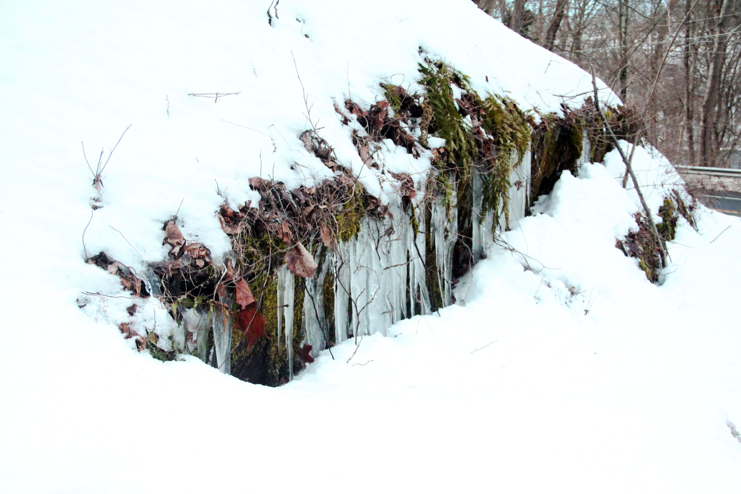
Even during the coldest, most frozen days of winter, flowing water will continue to move below the surface of ice and snow. Remarkably, snow and ice actually have an insulating quality that protects rivers and streams (and soil!) from fully freezing and arresting natural water movement. Areas in the landscape that refuse to fully freeze, or perhaps melt at a disproportionately faster rate, could imply there is regular water flow throughout the area. This constant water flow could be coming from a pond discharge, a seasonal creek, or perhaps even a natural spring!
Observations we make about water in our frozen landscape can inform thoughtful design in the form of water management, landscape orientation, and habitat creation.

A small spring creates rapid snow melt
Animal Use & Migration Patterns
Animal tracking is an art form, and without learned focus and protracted observation it’s often difficult for us to gain in-depth insight into animal usage and migration patterns through casual observation. Keeping in mind that populations and patterns will shift from season to season, a snow filled landscape can provide a wonderful opportunity to quickly observe the behaviors of our most seasonally long-term co-inhabitants.
Many animals obfuscate their movements to avoid predation. They roam and forage at night, or in the early morning. They wait for quiet, and absence, before they fill in the space with their tracks. Imprints in the snow, not only preserve information about what type of animals move through the space, but also the type of usage. Do the tracks enter and exist the property in a meandering but linear fashion, or do they circle, crisscross, and overlap? Becoming curious about these patterns can lead to observations about their preferred food source in winter, what plants are being predated, or even where they’ve nested or denned down for winter.
Snow tracks left by animals can even offer us insight into the underlying topographic orientation of our landscape. In sloped landscapes, ruminant animals like deer have a tendency to take a meandering path that mimics the contour fluctuations of the landscape. This ebb and flow to their approach limits the energy expenditure required to forge a trail straight uphill from point A to point B. Orienting our landscapes toward this relative ease in movement can help inspire the basic form and function of our roads and pathways, and ultimately help us reduce human, animal, and machine energy expenditure.

Deer tracks sway back and forth up a steep hillside

Tracks show the hunting patterns of a fox
Conclusion
Understanding our context before implementing landscape design creates the opportunity for collaborative relationships to evolve. Starting from a place of curiosity and inquiry can be an incredibly galvanizing place to begin the process of getting to know our environment. Each season brings with it its own set of unique vantage points from which to observe the unfolding relationships that surround us. The frozen landscape of a snowy winter is one such lens through which to read the world.
Content & Photos by Lindsay Napolitano, 2021
If you enjoy this content, or have something to contribute to the conversation,
please let us know and post in the comment section below!

Yoni Wolf, Fields without fences snow pup, 2021


